Loading... Please wait...
Categories
 New Products
-
 $4,200.00
-
 $5,250.00
-
 $4,550.00
-
 $3,150.00
-
 $4,200.00
Our Newsletter
- Home
- GPS GNSS SYSTEMS
- USED Topcon HiPer SR Network Rover GGD
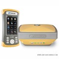
USED Topcon HiPer SR Network Rover GGD

Product Description
Topcon HiPer SR Network Rover GGD
The Topcon HiPer SR Network Rover GGD is an advanced device that helps people measure land and gather data very accurately. This technology is essential for professionals like surveyors, engineers, and builders. The Topcon HiPer SR is a GNSS (Global Navigation Satellite System) receiver. Think of it as a super-smart GPS that can tell you exactly where you are on Earth. It uses signals from satellites high above us to find precise locations. The HiPer SR is designed to work well with network RTK (Real-Time Kinematic) systems, which means it can get super accurate measurements almost instantly.
Why is Accurate Measurement Important?
Accurate measurements are crucial in many fields. For example:
- Construction: Builders need to know exactly where to place foundations and walls.
- Land Surveying: Surveyors measure land to determine property boundaries and create maps.
- Environmental Monitoring: Scientists track changes in land and ecosystems.
With devices like the HiPer SR, professionals can ensure their work is precise, which saves time and money.
Key Features of the Topcon HiPer SR
The Topcon HiPer SR Network Rover GGD comes with several impressive features that make it stand out. Let’s break down these features in simple terms.
1. Multi-Constellation GNSS Support
The HiPer SR can connect to multiple satellite systems, including:
- GPS (Global Positioning System)
- GLONASS (Russian satellite system)
- Galileo (European satellite system)
- BeiDou (Chinese satellite system)
This means it can use signals from different satellites to find your location. More satellites mean better accuracy!
2. Compact and Lightweight Design
One of the best things about the HiPer SR is its size. It is small and lightweight, making it easy to carry around. Surveyors and engineers can take it anywhere without feeling weighed down. This portability is perfect for outdoor work where you need to move from one spot to another.
3. Advanced RTK Functionality
RTK stands for Real-Time Kinematic. This feature allows the HiPer SR to provide very precise measurements in real time. Instead of waiting for data to be processed, users can see their location and measurements instantly. This is especially helpful for tasks that require immediate feedback, like construction projects.
4. Integrated Communication Options
The HiPer SR has built-in communication tools that make it easy to send and receive data. It supports:
- Bluetooth: This allows it to connect wirelessly to other devices, like smartphones and tablets.
- Cellular Connectivity: Users can connect to the internet to access correction data from nearby base stations. This helps improve accuracy even more.
These communication options make it simple for users to gather and share information quickly.
5. User-Friendly Interface
The HiPer SR is designed to be easy to use. It has a simple interface that anyone can understand, even if they are not tech experts. This means that even young users or beginners can operate the device without much training. The clear display shows important information, making it easy to read and interpret.
6. Durable Construction
When working outdoors, equipment can face harsh weather and rough conditions. The HiPer SR is built to be tough and durable. It can withstand rain, dust, and other environmental challenges. This durability ensures that the device will last a long time, even with regular use.
7. Long Battery Life
The HiPer SR is designed to work for long periods without needing to be recharged. This is important for surveyors who may spend hours in the field. A long battery life means they can focus on their work without worrying about running out of power.
How Does the Topcon HiPer SR Work?
Now that we know the features, let’s look at how the HiPer SR actually works. It’s a combination of technology and satellite signals that helps users get accurate measurements.
Step 1: Connecting to Satellites
When you turn on the HiPer SR, it starts searching for signals from satellites. It connects to multiple satellite systems to get the best possible data. The more satellites it connects to, the more accurate the location information will be.
Step 2: Receiving Correction Data
To achieve high accuracy, the HiPer SR uses correction data from nearby base stations. These base stations are fixed locations that send out signals to help improve the accuracy of the measurements. By using this data, the HiPer SR can correct any errors and provide precise location information.
Step 3: Real-Time Data Processing
Once the HiPer SR has connected to the satellites and received correction data, it processes this information in real time. Users can see their exact location and measurements instantly on the device’s display. This real-time feedback is crucial for making quick decisions in the field.
Step 4: Data Collection and Sharing
Users can collect data about the land, such as its dimensions, elevation, and other important features. The HiPer SR allows users to save this data and share it with others easily. This is especially useful for teams working together on projects, as everyone can access the same information.
Applications of the Topcon HiPer SR
The Topcon HiPer SR Network Rover GGD is used in various fields. Here are some common applications:
1. Land Surveying
Surveyors use the HiPer SR to measure land accurately. This helps determine property boundaries and create detailed maps. With its high precision, surveyors can ensure their work is reliable and trustworthy.
2. Construction
In construction, the HiPer SR is used to lay out buildings and other structures. Builders rely on accurate measurements to place foundations, walls, and other elements correctly. This helps prevent costly mistakes and ensures that projects are completed on time.
3. Environmental Monitoring
Scientists and researchers use the HiPer SR to monitor changes in the environment. For example, they can track changes in land use, vegetation growth, or erosion. This data is essential for understanding how human activities impact the environment.
4. Agriculture
Farmers can also benefit from the HiPer SR. It helps them map their fields, track crop growth, and manage irrigation systems. By using precise measurements, farmers can make better decisions that improve their yields.
5. Mining and Resources
In mining and resource management, the HiPer SR helps map out areas for exploration and extraction. Accurate measurements are crucial for planning and ensuring that resources are used efficiently.
Conclusion
The Topcon HiPer SR Network Rover GGD is an incredible tool that brings advanced technology to the world of surveying and construction. With its multi-constellation support, compact design, and real-time accuracy, it empowers professionals to work more efficiently and effectively. Whether it’s measuring land, building structures, or monitoring the environment, the HiPer SR plays a vital role in helping us understand and manage our world better.
By using devices like the HiPer SR, we can ensure that our work is precise, reliable, and beneficial for everyone. As technology continues to advance, tools like the HiPer SR will remain essential for professionals in various fields, making our lives easier and our projects more successful.
Includes:
- Topcon Hiper SR Receiver
- OAF, HiPer SR, Network Only RTK, GGD 10Hz
- Topnet 40hr Licence Incl Sim card
- FC-500 GEO +3G Controller with Pole Bracket
- Magnet Field GPS Software
- GPS Composite Pole
- Topcon Easycare
Warranty Information

Customers Who Viewed This Product Also Viewed
-
 $2,850.00
-
 $4,620.00
-
 $4,480.00
-
 $1,540.00
Add to Wish List
Related Products
-

-
 USED Topcon Hiper V GNSS Base Rover Kit $4,000.00
-
-
-