 Loading... Please wait...
Categories
 New Products
-
 $4,200.00
-
 $5,250.00
-
 $4,550.00
-
 $3,150.00
-
 $4,200.00
Our Newsletter
- Home
- GROUND PENETRATING RADAR
- USED MALA Professional Explorer GPR
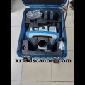
USED MALA Professional Explorer GPR

Product Description
MALA Professional Explorer GPR
The MALA Professional Explorer GPR is a state-of-the-art Ground Penetrating Radar (GPR) system designed for high-performance subsurface imaging and analysis. This advanced technology is widely used in various fields, including civil engineering, archaeology, environmental studies, and utility detection. Ground Penetrating Radar (GPR) is a non-destructive geophysical method that uses radar pulses to image the subsurface. It sends high-frequency radio waves into the ground, which then reflect off different materials and structures. The returned signals are processed to create images that reveal what lies beneath the surface, allowing for detailed analysis without excavation.
How Does the MALA Professional Explorer Work?
The MALA Professional Explorer operates by emitting radar signals into the ground. When these signals encounter different materials, such as soil, rock, or buried objects, they reflect back to the scanner. The system captures these reflections and processes them to generate high-resolution images of the subsurface, enabling users to identify and analyze various features.
Key Features of the MALA Professional Explorer
The MALA Professional Explorer GPR is equipped with several advanced features that enhance its performance and usability:
1. High-Resolution Imaging
- Detailed Data Capture: The system provides high-resolution images, allowing users to identify small objects and structures beneath the surface with exceptional clarity.
2. Versatile Antenna Options
- Multiple Frequencies: The Professional Explorer can be equipped with different antennas, enabling it to adapt to various ground conditions and project requirements. This flexibility enhances its effectiveness in diverse applications.
3. User-Friendly Interface
- Intuitive Operation: The system features a user-friendly interface that simplifies operation, making it accessible for both experienced professionals and newcomers to GPR technology.
4. Lightweight and Portable Design
- Easy to Transport: The MALA Professional Explorer is designed to be lightweight and portable, allowing users to easily carry it to various job sites for fieldwork.
5. Real-Time Data Visualization
- Instant Feedback: The system offers real-time data visualization, allowing users to see results immediately as they scan. This feature is crucial for making quick decisions during surveys.
Applications of the MALA Professional Explorer
The versatility of the MALA Professional Explorer makes it suitable for a wide range of applications across different industries:
1. Utility Detection
In utility detection, the Professional Explorer is invaluable for locating underground utilities, such as:
- Water Pipes: Identifying the location of water lines to prevent damage during excavation.
- Gas and Electric Lines: Locating gas and electrical cables to ensure safety during construction and maintenance work.
2. Civil Engineering
In civil engineering, the MALA Professional Explorer is used for:
- Site Investigation: Conducting subsurface investigations to assess soil conditions and identify potential hazards before construction.
- Quality Control: Ensuring that construction aligns with design specifications by comparing scans to CAD models.
3. Archaeology
Archaeologists utilize the Professional Explorer to explore historical sites without disturbing the ground. This technology allows them to:
- Document Sites: Capture detailed 3D models of archaeological sites and artifacts for preservation and study.
- Analyze Structures: Study ancient structures and landscapes without invasive methods.
4. Environmental Studies
Environmental scientists use the MALA Professional Explorer for:
- Contamination Detection: Locating hazardous waste or pollutants in the soil.
- Groundwater Analysis: Understanding the levels and flow of groundwater for effective resource management.
Benefits of Using the MALA Professional Explorer
The MALA Professional Explorer offers numerous benefits that make it a preferred choice for professionals in various fields:
1. Efficiency
The system’s ability to provide quick and accurate results leads to faster project completion. This efficiency can save time and reduce costs significantly.
2. Enhanced Safety
By locating underground utilities and hazards, the Professional Explorer improves safety for workers on job sites. Knowing what’s below helps prevent accidents and damage.
3. High Accuracy
The high-resolution images produced by the MALA Professional Explorer ensure that users can make informed decisions based on reliable data, leading to successful project outcomes.
4. Environmentally Friendly
Since GPR is a non-destructive method, it is a more environmentally friendly option compared to traditional excavation techniques. It helps preserve the natural state of the ground.
How to Use the MALA Professional Explorer
Using the MALA Professional Explorer is straightforward. Here’s a simple step-by-step guide:
Step 1: Set Up the Equipment
- Choose Antenna: Select the appropriate antenna based on the project requirements.
- Power Up: Turn on the device and ensure it is fully charged.
Step 2: Prepare the Area
- Clear the Surface: Make sure the area is free of obstacles that could interfere with the radar signals.
Step 3: Conduct the Survey
- Scan the Ground: Move the MALA Professional Explorer across the area you want to analyze. The device will send radar waves into the ground.
- Monitor Data: Watch the real-time data on the screen as you scan. This provides immediate feedback on what’s below.
Step 4: Analyze the Results
- Review Images: Once the scanning is complete, review the high-resolution images produced by the MALA Professional Explorer.
- Make Decisions: Use the information to make informed decisions about the next steps in your project.
Conclusion
The MALA Professional Explorer GPR is a powerful tool that enables users to explore what lies beneath the Earth’s surface without any digging. Its advanced technology, user-friendly design, and versatility make it a favorite among professionals in various fields. Whether it’s for utility detection, civil engineering, archaeology, or environmental studies, the MALA Professional Explorer proves to be an invaluable asset.
By understanding how the MALA Professional Explorer works and its various applications, users can appreciate the importance of this technology in helping us learn more about our world. So, the next time you hear about construction projects or archaeological digs, remember that tools like the MALA Professional Explorer are making it all possible!
Includes:
- ProEx Control Unit
- ProEx Module – Optical
- Li-ion Battery 11.1 V/6.6 Ah (15 pin)
- Li-ion Battery Charger 12.6 V H01110030 incl. EU/UK/US power cord
- Ethernet Communication Cable 1.2 m (black)
- Ethernet Communication Cable 3.0 m (black)
- MALA USB Software and Manuals Package
- Shipping Case for ProEx Control Unit
- MHz Shielded Electronics Unit
- 3m Multi-fiber cable for 100-800 MHz Shielded Antenna System
- Li-ion Battery 11.1 V/6.6 Ah (15 pin)
- Li-ion Battery Charger 12.6 V H01110030 incl. EU/UK/US power cord
- Backpack for ProEx
- Monitor/PC Holder for ProEx & CUII (attach to backpack)
Warranty Information

Customers Who Viewed This Product Also Viewed
-
 $3,500.00
-
 $3,000.00
-
 $2,350.00
-
 $3,850.00
Add to Wish List
Related Products
-
 BRAND NEW Prodim Proliner 8 3D $3,675.00
-

-
 BRAND NEW MALA Professional Explorer GPR $6,300.00
-

-
 BRAND NEW SciAps X-555 $4,900.00