Loading... Please wait...
Categories
 New Products
-
 $4,200.00
-
 $5,250.00
-
 $4,550.00
-
 $3,150.00
-
 $4,200.00
Our Newsletter
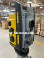
USED GeoMax Zoom95

Product Description
GeoMax Zoom95
The GeoMax Zoom95 is a cutting-edge GNSS (Global Navigation Satellite System) receiver designed for professionals in surveying, construction, and geospatial applications. This device combines advanced technology with user-friendly features, making it an essential tool for anyone needing accurate positioning data. The GeoMax Zoom95 is a high-performance GNSS receiver that provides precise location data by connecting to multiple satellite systems. It is ideal for a variety of applications, including land surveying, mapping, and construction site management. With its robust design and advanced features, it ensures reliable performance in any environment.
Key Features of GeoMax Zoom95
1. Multi-Constellation Support
The Zoom95 supports multiple satellite systems, including GPS, GLONASS, Galileo, and BeiDou. This multi-constellation capability ensures that users can achieve accurate positioning no matter where they are in the world.
2. High Accuracy
With advanced algorithms and real-time kinematic (RTK) capabilities, the GeoMax Zoom95 delivers exceptional accuracy, often within a few centimeters. This level of precision is crucial for tasks like land surveying and construction layout.
3. Rugged and Durable Design
Built to withstand harsh conditions, the Zoom95 features a rugged design that is resistant to water, dust, and impacts. This durability makes it suitable for outdoor use, ensuring reliability even in challenging environments.
4. User-Friendly Interface
The GeoMax Zoom95 is designed with ease of use in mind. It features an intuitive interface that allows users to navigate the device effortlessly. Whether you are a seasoned professional or a newcomer, you will find it easy to operate.
5. Wireless Connectivity
With built-in Bluetooth and Wi-Fi, the Zoom95 allows for seamless data transfer and communication with other devices. This connectivity facilitates real-time collaboration and data sharing, enhancing productivity on the job site.
Applications of GeoMax Zoom95
The GeoMax Zoom95 is versatile and can be used in various fields. Here are some common applications:
1. Land Surveying
Surveyors rely on the Zoom95 for accurate measurements and mapping. Its high precision helps define property boundaries and create detailed topographic maps.
2. Construction
In construction, the GeoMax Zoom95 is used for site layout, ensuring that structures are built in the correct locations. This minimizes errors and improves overall project efficiency.
3. Agriculture
Farmers can use the Zoom95 for precision agriculture, helping them optimize planting, irrigation, and harvesting processes. This technology leads to better crop yields and resource management.
4. Environmental Monitoring
Researchers and environmentalists utilize the Zoom95 to gather data for studies related to land use, conservation, and ecological changes. Its accuracy helps in assessing environmental impacts accurately.
Benefits of Using GeoMax Zoom95
Using the GeoMax Zoom95 comes with numerous advantages:
1. Enhanced Efficiency
The high accuracy and reliability of the Zoom95 allow for faster data collection and analysis, saving time and resources on projects.
2. Increased Confidence in Data
With precise measurements, users can trust the data collected, leading to better decision-making and project outcomes.
3. Flexibility in Use
The Zoom95 is suitable for a wide range of applications, making it a versatile tool for professionals across different industries.
4. Learning and Development
For students and new professionals, using the GeoMax Zoom95 can provide hands-on experience with advanced surveying technology, enhancing their skills and knowledge.
Conclusion
The GeoMax Zoom95 is an exceptional GNSS receiver that combines advanced technology with user-friendly features. Its high accuracy, rugged design, and versatility make it an indispensable tool for surveying, construction, agriculture, and environmental monitoring. Whether you are a professional or a student, the GeoMax Zoom95 can help you achieve your goals with confidence and precision. If you're looking for a reliable and efficient solution for your positioning needs, the GeoMax Zoom95 is definitely worth considering!
Includes:
- ZMS108 USB Memory Stick 8GB
- ZBA400, Li-Ion Battery 4.4Ah
- ZCH201 Charger for ZBA201 & ZBA400 Li-Ion batteries
- ZTR201 Advanced Tribrach without optical plummet, black
- ZRT82, Long-Range Bluetooth Handle for GeoMax Zoom70/75/90/95 total station
- GRZ122, 360° reflector with 5/8" thread
- ZPC201 Telescopic Carbon Fibre and aluminium pole with stub for TPS, extends to 2.3 m
- ZDC301 USB cable Mini-USB to USB Host (Zipp10/Zipp20/Zoom40/Zoom90/Zoom95 to a PC/Tablet)