 Loading... Please wait...
Categories
 New Products
-
 $4,200.00
-
 $5,250.00
-
 $4,550.00
-
 $3,150.00
-
 $4,200.00
Our Newsletter
- Home
- TOTAL STATIONS
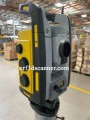
- USED LEICA NOVA MS50 1″ MULTISTATION
USED LEICA NOVA MS50 1″ MULTISTATION

Product Description
LEICA NOVA MS50 1″ MULTISTATION
The Leica Nova MS50 1″ MultiStation is a cutting-edge surveying instrument that combines the best features of traditional total stations and advanced 3D laser scanning. This remarkable tool is designed for professionals in various fields, including construction, mining, and environmental monitoring. The Leica Nova MS50 1″ MultiStation is a sophisticated device used to measure distances, angles, and 3D coordinates with high precision. Imagine it as a super-smart tool that helps surveyors and engineers gather important information about land and structures.
Combining Multiple Functions
One of the standout features of the MS50 is its ability to combine several functions into one device:
- Total Station: This part measures angles and distances very accurately, making it ideal for creating maps and plans.
- 3D Laser Scanner: The MS50 can capture thousands of measurements in a short period, creating detailed 3D models of the surveyed area.
- GPS Integration: It can also use GPS technology to determine its exact location on Earth, enhancing its versatility.
By integrating these functions, the Leica Nova MS50 makes it easier and faster to collect critical data.
How Does the Leica Nova MS50 Work?
User-Friendly Touchscreen Interface
The Leica Nova MS50 features a large, intuitive touchscreen that allows users to operate the device easily. You can navigate through options by simply tapping the screen, similar to using a tablet or smartphone. This user-friendly design ensures that even beginners can learn to use the equipment quickly.
Accurate Measurements
To measure distances and angles, the MS50 uses a laser beam. The laser sends out light that travels to the target and back. By calculating the time it takes for the light to return, the device can determine the distance accurately. It also measures angles, which is crucial for creating precise maps.
Creating 3D Models
The 3D laser scanning capability is one of the most exciting features of the MS50. It can capture thousands of points in just a few seconds, allowing it to create a detailed 3D representation of the surveyed area. This technology is especially useful for architects and engineers who need to visualize projects before construction begins.
Why is the Leica Nova MS50 Important?
Applications Across Various Industries
The Leica Nova MS50 MultiStation is used in many different fields. Here are some examples of where it proves to be invaluable:
Construction
In the construction industry, precise measurements are crucial. Builders use the MS50 to lay out foundations, ensuring everything is correctly positioned. It helps check the height and alignment of structures, which is vital for safety and quality.
Mining
In mining operations, the MS50 is essential for measuring stockpiles of materials like coal or ore. This information helps companies manage resources effectively and plan their operations. Additionally, it assists in mapping underground tunnels and other geological features.
Infrastructure Development
For infrastructure projects, such as roads and bridges, the MS50 helps engineers survey the land before construction. It ensures that designs are suitable for the terrain, which is crucial for the durability and safety of the structures.
Environmental Monitoring
The MS50 can also be used to monitor changes in the environment. For example, it can measure the growth of trees in a forest or track changes in a river's course. This information is vital for conservation efforts and understanding environmental changes.
Advantages of Using the Leica Nova MS50
Exceptional Accuracy
One of the most significant advantages of the Leica Nova MS50 is its accuracy. It can measure distances with millimeter precision, ensuring that the data collected is reliable and correct.
Speed of Operation
The MS50 is incredibly fast. It can take thousands of measurements in just a few seconds, saving time on projects and allowing workers to complete tasks more efficiently.
Durability
The Leica Nova MS50 is built to withstand harsh conditions. It can handle rain, dust, and other environmental challenges, making it suitable for various outdoor applications.
Easy Data Management
The data collected by the MS50 can be easily transferred to computers and software programs for analysis. This capability simplifies the process of creating reports, maps, and other essential documents, allowing professionals to make informed decisions quickly.
Conclusion
The Leica Nova MS50 1″ MultiStation is an incredible tool that revolutionizes the way surveying and measuring are done. By combining the functions of a total station and a 3D laser scanner, it provides valuable information across many industries, including construction, mining, and environmental monitoring. Its user-friendly design, high accuracy, speed, and durability make it an essential instrument for professionals.
Whether you’re involved in building a new bridge, mapping a forest, or planning a construction project, the Leica Nova MS50 is there to assist. With this advanced technology, we can better understand our world and make smarter decisions for the future. So, the next time you see a surveyor or engineer at work, remember that tools like the Leica Nova MS50 are making their tasks easier and more efficient!
Warranty Information

Customers Who Viewed This Product Also Viewed
-
 $6,300.00
-
 $2,750.00
-
 $4,200.00
-
 $3,150.00
Add to Wish List
Related Products
-

-
 BRAND NEW Leica Nova MS60 MultiStation $6,300.00
-
-
USED Leica Nova MS60 MultiStation $4,500.00
-
USED Leica Nova TM50 R1000 Monitoring $2,750.00