 Loading... Please wait...
Categories
 New Products
-
 $4,200.00
-
 $5,250.00
-
 $4,550.00
-
 $3,150.00
-
 $4,200.00
Our Newsletter
- Home
- GPS GNSS SYSTEMS
- BRAND NEW TOPCON HIPER HR GNSS
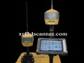
BRAND NEW TOPCON HIPER HR GNSS

Product Description
HiPer HR GNSS Receiver
The HiPer HR GNSS Receiver is a high-performance Global Navigation Satellite System (GNSS) device designed for precise positioning and surveying applications. It is widely used in various fields, including construction, land surveying, agriculture, and geospatial analysis.
What is the HiPer HR GNSS Receiver?
The HiPer HR is a versatile GNSS receiver that provides accurate positioning data by receiving signals from multiple satellite constellations. It is designed for both static and dynamic applications, allowing users to achieve high precision in their measurements.
Key Features of the HiPer HR GNSS Receiver
1. High Accuracy
The HiPer HR offers exceptional accuracy, often achieving centimeter-level precision. This is crucial for tasks like land surveying and construction, where precise measurements are essential.
2. Multi-Constellation Support
The receiver supports multiple satellite systems, including GPS, GLONASS, Galileo, and BeiDou. This multi-constellation capability ensures reliable performance, even in challenging environments with limited satellite visibility.
3. Advanced Signal Processing
The HiPer HR employs advanced signal processing technology, which enhances the quality of the received signals. This improves accuracy and reliability, especially in urban areas with tall buildings or other obstructions.
4. User-Friendly Interface
The device features an intuitive interface that makes it easy to operate. Even those who are new to GNSS technology can quickly learn how to use the HiPer HR effectively.
5. Lightweight and Portable
The HiPer HR is designed to be lightweight and portable, making it easy for surveyors to carry it around different job sites. This portability is essential for professionals who need to work in various locations throughout the day.
6. Long Battery Life
With an extended battery life, the HiPer HR can operate for long periods without needing a recharge. This is particularly important for large projects where downtime can be costly.
How Does the HiPer HR GNSS Receiver Work?
Setting Up the Receiver
To use the HiPer HR GNSS Receiver, the user first sets it up at a known location. This can be done on a tripod or a stable surface. Once the receiver is set up, it connects to satellites to start receiving signals.
Receiving Satellite Signals
The HiPer HR uses antennas to receive signals from multiple satellites. By calculating the time it takes for these signals to travel from the satellites to the receiver, the system can determine its exact position on Earth.
Real-Time Positioning
The HiPer HR can provide real-time positioning data, allowing users to see their location instantly. This feature is essential for surveying tasks where immediate feedback is necessary.
Applications of the HiPer HR GNSS Receiver
1. Land Surveying
Land surveyors use the HiPer HR to measure land boundaries, create topographic maps, and gather data for construction projects. Its high accuracy is essential for planning and legal purposes.
2. Construction
In the construction industry, the HiPer HR helps builders lay out foundations, walls, and other structures accurately. By ensuring that everything is measured correctly, it reduces the risk of costly mistakes during construction.
3. Agriculture
Farmers and agricultural professionals use the HiPer HR for precision farming. By accurately mapping fields and managing resources, they can increase crop yields and reduce waste.
4. Environmental Monitoring
The HiPer HR is also used in environmental studies. Researchers can monitor changes in land use, track wildlife, and assess the impact of human activities on the environment.
5. Infrastructure Development
For infrastructure projects like highways and railways, the HiPer HR provides the necessary data to ensure that designs are accurate and safe. Engineers rely on this information to plan and execute large-scale projects effectively.
Benefits of Using the HiPer HR GNSS Receiver
1. Increased Efficiency
The HiPer HR GNSS Receiver increases efficiency in surveying and construction. With its real-time positioning capabilities, surveyors can complete their work faster, saving time and resources.
2. Improved Accuracy
The high accuracy of the HiPer HR ensures that measurements are reliable. This is crucial for avoiding errors that could lead to costly rework or project delays.
3. Cost Savings
By reducing mistakes and increasing efficiency, the HiPer HR can save money in the long run. Fewer errors mean less rework, which is beneficial for any project.
4. Versatility
The HiPer HR is versatile and can be used in various applications, from construction to environmental studies. This flexibility makes it a valuable tool for many professionals.
Conclusion
The HiPer HR GNSS Receiver is a powerful and versatile tool that plays a crucial role in surveying, construction, and environmental monitoring. With its high accuracy, multi-constellation support, and user-friendly interface, it is designed to meet the needs of professionals in the field.
Warranty Information

Customers Who Viewed This Product Also Viewed


Add to Wish List
Related Products
-
 USED Topcon Hiper V GNSS Base Rover Kit $4,000.00
-
 USED Topcon HiPer SR Network Rover GGD $3,250.00
-

-
 USED TOPCON HIPER HR B R $4,500.00
-